November 18, 2020 is the 22nd annual GIS Day – the day that users of GIS technology across the world come together to acknowledge, celebrate, share, and demonstrate real-world applications that are making a difference in society.

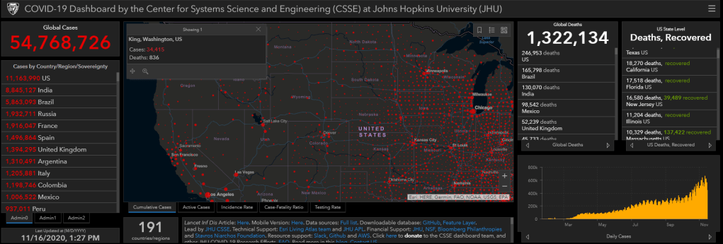
With the impact of COVID-19 on the rise across the globe, GIS Day 2020 is like no other. And because of COVID-19, GIS is more important than ever. One year ago, few people knew what a GIS-based dashboard was. In January, 2020, Dr. Lauren Gardner of the Johns Hopkins Center for System Science and Engineering developed the COVID-19 dashboard. When we wrote about this dashboard in GIS & You in mid-February, barely 50,000 cases had been identified. Today, the Johns Hopkins University Coronavirus Map has been seen and used by billions of people around the world.
On GIS Day 2019, the 30 or so GIS professionals who make up the King County GIS Center team could usually be found together in our Seattle offices, on the second floor of King Street Center. Since March of this year we have mostly been in WFH status – working from home. Today we are spread across at least four counties, but still working effectively to put GIS to work for King County and the communities that we serve. What have we accomplished in the past year?
The relatively smooth transition to working remotely has been a big success, but most important has been our ability to continue supporting those who use GIS within King County government and beyond. King County, with 2.2 million residents, has about 15,000 employees. More than 6,000 of those employees use GIS-based web mapping applications. As many as 1000 county employees use advanced GIS software, including:
- ArcMap: 477 users
- ArcGIS Pro: 212 users
- EagleView/Pictometry: 231 users
- Nearmap: 99 users
All of these users are supported by the King County GIS Center’s cadre of GIS professionals.
During the past year we have spotlighted many of our projects in previous GIS & You articles:
- In November 2019 Jeffrey Linn wrote about using lidar-derived imagery to show the twisting patterns of riverbeds in a novel way — as bright, colorful images on a black background. King County’s Water & Land Resources Division used this spatial data visualization technique for habitat enhancement planning along the Green River, near Flaming Geyser State Park.
- Later in February I wrote about the launch of a project to develop GIS for Equity & Social Justice Best Practices. In October the document was published by the American Geographical Society EthicalGEO project, and soon it will be published as a new article in the GIS&T Body of Knowledge.
- Also in February, George Horning wrote about our recently completed 2019 GIS aerial imagery project. And in April, Patrick Jankanish wrote about the processing of the 2019 aerial photography into a GIS-compatible data resource.
- Early in March, Jeffrey Linn published another article, focusing on the use of animated 3D data to show the impact on the Duwamish River basin of a hypothetical 2-foot sea level rise.
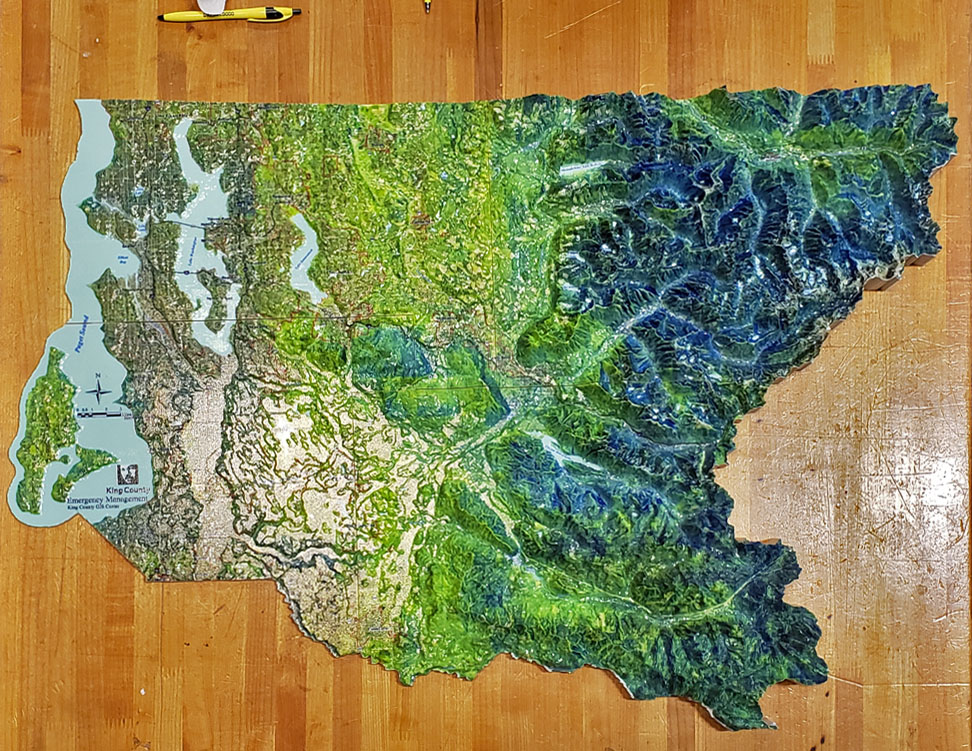
- An unusual project completed during the past year was the development of a large 3D physical model of King County for King County Office of Emergency Management, for public meeting purposes. This project involved generating a GIS 3D file used by a vendor with 3D printing technology to complete the model. Victor High and Jeffrey Linn each wrote about this interesting project from their own perspective.
- In June, I interviewed Mary Ullrich, Fred Lott, and Dennis Higgins over ‘virtual coffee’ to discuss their involvement using GIS for a variety of equity and social justice projects.
- Later in the summer Fred Lott wrote about his work on the Local Food Finder app, to support King County’s Agriculture and Food Program help local farmers connect with potential customers looking for healthy, locally-sourced products.
- Victor High published a new storymap about the History of Lidar in King County. This article received accolades by many in the GIS community for helping to make this technology easy to understand.
- And Dennis Higgins wrote about our work helping Public Health – Seattle & King County promote COVID-19 testing sites around King County.
King County GIS supports thousands of GIS users, within King County and across the region, with access to data and web-based GIS tools. We also work on more challenging projects for a variety of customers. Interesting projects completed or in progress include:
- Helping the King County Prosecuting Attorney’s Office set up an ArcGIS Portal environment that is CJIS (Criminal Justice Information Services) compliant.
- Affordable housing analysis for the King County Department of Community & Human Services
- Covid-19 small business geocoding for the King County Department of Local Services
- GIS basemap implementation support for Community Transit
- Ongoing GIS support for the Urban Indian Health Institute of Seattle.
King County GIS also helps county employees and GIS users from around the world ‘put GIS to work’ more effectively through our GIS training program. One year ago, King County GIS Trainer Mary Ullrich was teaching a three-day Intermediate ArcGIS Pro class in our Seattle GIS training facility. After COVID-19 resulted in cancellation of face-to-face events, we pivoted our training to online, via Zoom. As this article is being published, Mary is again teaching the Intermediate ArcGIS-Pro class, but this time online. During the past year we have taught more than 300 students:
- ArcGIS Pro Quickstart for the GIS Professional: 5 sessions with 38 students
- Introduction to ArcGIS Pro: 4 sessions with 24 students
- Intermediate ArcGIS Pro: 3 sessions with 15 students
- ArcGIS Enterprise Administrative Workflows: 1 session with 15 students
- GIS for Equity & Social Justice: 9 sessions with 210 students
- GIS Program Management: 1 session with 14 students
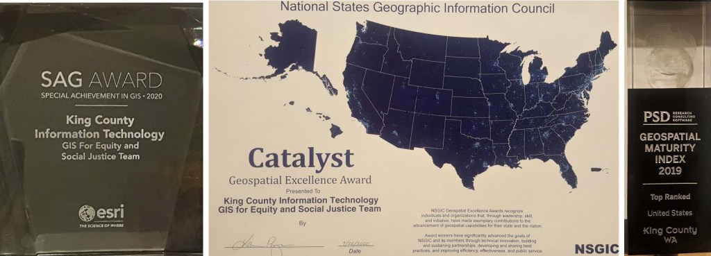
During the past year, the King County GIS Center received three awards:
- The PSD 2019 Geospatial Maturity Assessment found King County the top-ranked agency in the United States for Geospatial Maturity
- The King County IT GIS for Equity and Social Justice team received the Esri 2020 Special Achievement in GIS Award.
- The National States Geographic Information Council awarded its Geospatial Excellence Catalyst Award to the King County IT GIS for Equity and Social Justice team.
What is in store for the next year for King County GIS Center? We are always looking to the future. We anticipate new team members, new projects, new challenges, and new accomplishments. We will be adding a new class to our curriculum in 2020 – Advanced ArcGIS Pro. The Sound to Summit Regional GIS project will be completed. More Equity and Social Justice datasets will be published and dashboards developed. And we are working with the State of Washington to develop a statewide digital equity dashboard.
Check GIS & You frequently for new articles to learn what we are working on…
…and Happy GIS Day!


Hi,
My name is Awais and lives in KSA since 1994. A young and energy person with having 13 years of professional experience. I am also very keen to work in Canada.
Thanks,
LikeLike