Back in November I reported on the award of seven EthicalGEO Fellowships by the American Geographical Society. My EthicalGEO Fellowship project is to develop and publish a first-ever GIS for Equity and Social Justice best practices document. The seven EthicalGEO Fellows first met on November 21, 2019 at Columbia University to present their proposals. This meeting was sponsored by the American Geographical Society and the Omidyar Network, the EthicalGEO funding sponsor. So what is the progress on this project?
The goal of my project is to develop effective guidelines for applying geospatial technology and data by government agencies and non-profits for issues related to equity and social justice (ESJ). Bill and Melinda Gates recently wrote about the key role of race and place in determining chances for long-term success in life. The benefits of GIS for ESJ Best Practices will include:
• Make the work of GIS professionals effective and efficient on a repeatable basis.
• Enable GIS professionals to provide consulting and assistance to ESJ practitioners who are new to using GIS for their work.
• Create an environment where GIS for ESJ work is recognized as grounded in good science and analysis.
• Help guard against those who will certainly deny the validity of GIS for ESJ analysis.
A key question that I had was where to publish the GIS for ESJ Best Practices, once they have been completed? Last year I secured agreement from John Wilson, Editor in Chief, to have them added as a new topic for the Geographic Information Science and Technology Body of Knowledge (GIS&T BOK). This will be a topic within the GIS &T and Society domain.
I sent out a call for volunteers to contribute to this effort at the end of 2019. In addition to inviting participation in my November GIS & You article, I also reached out via a URISA News Announcement and URISA’s GIS for ESJ Workgroup, via a posting to the GARE (Government Alliance on Race Equity) discussion forum, and the GIS for ESJ LinkedIn group.
I now have a list of 55 volunteers, including representation from government, private, academia, healthcare, and non-profits sectors. 34 of these volunteers attended a kick-off conference call on January 28. A second call attended by 10 core team members helped refine the working outline for the best practices.
The working outline for this project includes the following sub-topics:
- Why GIS for ESJ best practices?
- Ensuring a voice for the community
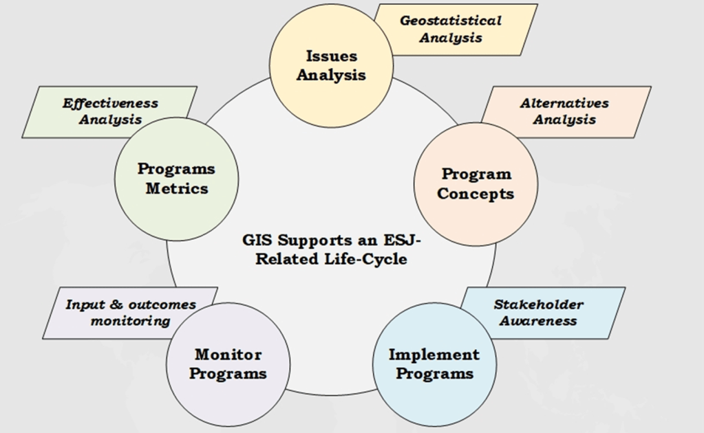
- GIS for ESJ conceptual life-cycle
- Domains of GIS for ESJ best practices:
- Definitions
- Spatial data management
- Spatial data sources
- Geospatial analytical practices
- Cartographic practices
- General visualization practices
- GIS based dashboards for ESJ program monitoring
- Recommended resources
During the next month-and-a-half work will focus on drafting content for this outline. This will include intensive literature search. By April the core team will be re-mobilized to review and agree on an initial draft that is suitable for peer-review. This peer-review cycle will be publicized again via URISA, GARE, and LinkedIn, but you can always contact me if you’d like to be kept informed when the draft is ready.
I will be reporting back to AGS on progress on a regular basis, including an EthicalGEO Fellows meeting in June. I will also be speaking about progress on this effort at several up-coming events, including:
- A possible GIS for ESJ event in San Jose, April 1-2, sponsored partly by BayGEO (the Bay Area URISA Chapter)
- The GARE Annual meeting in Portland, April 14-16
- GIS in Action (the Oregon URISA Chapter) in Portland, April 21-22
- The Washington GIS Conference in Tacoma, May 19-21
- Esri User Conference in San Diego, July 13-17
Please contact me (greg.babinski@kingcounty.gov) if you would like to learn more or to get involved.


Pingback: GIS Day 2020 – King County GIS looks back and looks to the future | GIS & You