 You have a table of addresses locating your assets but how do you figure out if they are within a specific ZIP Code, census tract, service area, or council district? One workflow is to utilize ArcGIS for Desktop to locate the addresses and then compare their locations to the geography of interest. This requires specialized knowledge and software, so you may want to consider using ArcGIS Maps for Office. Maps for Office is an Excel add-in that allows you to create maps within an Excel spreadsheet using the ArcGIS Online platform.
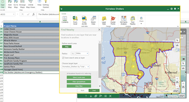
Once ArcGIS Maps for Office is installed you can open your spreadsheet and get right to work. For example, you have a spreadsheet of addresses locating assets and you want to know which ones are in King County Council District 1. You can add a map to the spreadsheet and use King County’s address locator to create points on the map representing the assets. Then you add the Council Districts layer to the map from the ArcGIS Online cloud. By selecting District 1, you can use the Find Nearby tool to select the addresses that are in the district. The final step is to filter the spreadsheet to show just the records needed.
In a manner of minutes, and right within Excel, you can use ArcGIS Maps for Office to answer your questions. While working, you can use other tools in Maps for Office to fix errors in the data, learn about the demographics in your area of interest, and generate a report.
Learn more about ArcGIS Maps for Office here. To use ArcGIS Maps for Office, you will need an ArcGIS Online subscription account. (If you are a King County employee, please contact George Horning.)
Want some training to help you use ArcGIS Maps for Office? Consider registering for Mapping Data with ArcGIS Maps for Office, scheduled for September 22 in Seattle.
Mary Ullrich is a GIS analyst and trainer in the KCGIS Center Client Services group.


