King County has added to its collection of high-resolution aerial imagery. Local jurisdictions can share in the bounty.
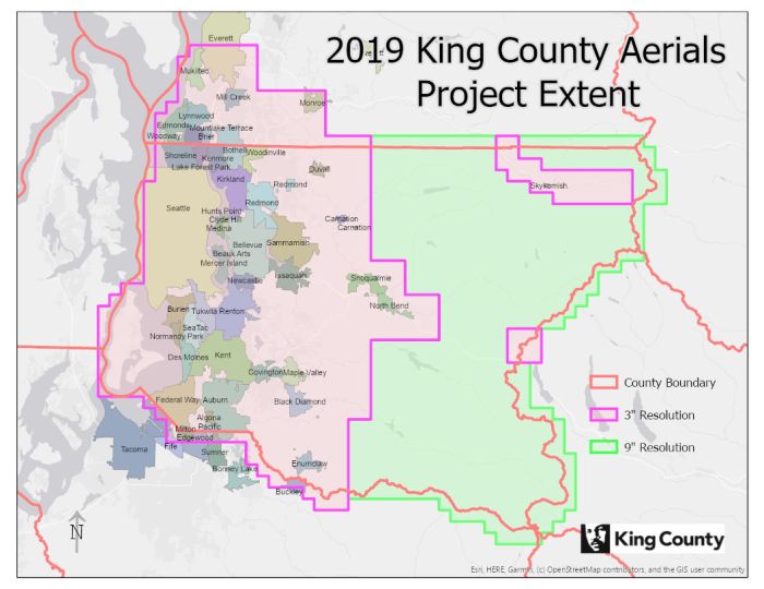
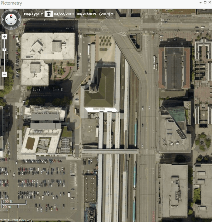
Collecting high resolution aerial imagery is habit forming, at least it is for King County. We have been doing it on a regular basis since 2007, and we continued in 2019. The 2019 acquisition captured three-inch-resolution orthogonal imagery for western King County and southwestern Snohomish County, and nine-inch-resolution for eastern King County.
Under contract for 2019 and future acquisitions is EagleView Technologies. The contract runs for ten years with future acquisitions scheduled for 2021, 2023, 2025 and 2027. To ensure the imagery meets the county’s specifications we engaged Miller Creek Associates, to perform data acceptance testing (DAT).
At the completion of the EagleView contract we will have imagery for every other year from 2007 to 2027. Besides providing current imagery to support our business needs, we are also building a valuable resource for studying the history of a rapidly evolving region.
Information for jurisdictions to arrange imagery cost sharing with King County.
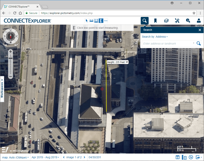
King County negotiated shared ownership with EagleView of the orthogonal imagery, which means we can distribute copies of the 2019 imagery to governmental organizations within the project extent. Our agreement also allows our cost-share partners to access to the oblique and orthogonal imagery via EagleView’s CONNECTExplorer SaaS solution.
CONNECTExplorer includes features to search and retrieve the imagery, functionality to measure distance, area, height, and elevation of objects on the oblique imagery, as well as the ability to overlay GIS content. EagleView also has extensions for viewing the imagery with ArcMap or ArcGIS Pro. The entire library of King County’s EagleView imagery dating back to 2005 is available via these tools.
To cost share, jurisdictions select the tiles they wish to purchase from a 3750-foot grid, which is available for download. Each tile measures 3,750 feet on a side and has an area of approximately one-half square mile. Jurisdictions only pay for the tiles they select based on a 50/50 cost-share split with King County. Included with the cost share are a set number of CONNECTExplorer accounts allowing access to the complete collection of King County oblique imagery.
Based on the information provided by a jurisdiction, King County will calculate the cost share and generate a statement and an invoice. Upon written acceptance of the invoice the orthogonal imagery for the selected tiles will be loaded on a hard drive provided by the organization. Delivery will be by mail or pickup. CONNECTExplorer accounts for the organization will be created based on staff names and emails that are provided. Links to download the executables necessary to install the viewing extensions in ArcMap and ArcGIS Pro will also be provided.
For more information about the cost share opportunity please contact George Horning, King County GIS Center Manager at george.horning@kingcounty.gov or 206-477-4401.


Pingback: 2019 Aerial Imagery: from camera to map | GIS & You
Pingback: GIS Day 2020 – King County GIS looks back and looks to the future | GIS & You