The King County Department of Elections conducts all elections by paper ballot, which a voter either mails or deposits into one of nearly 70 drop boxes that are distributed throughout the county. For its secure tracking of drop-box collections, Elections transitioned in the spring of 2019 to an all-digital workflow using mostly Esri GIS products. The all-digital aspect is notable in part because this is not yet common practice among elections agencies.
 The tracking process starts with dispatchers assigning work orders to more than 20 teams of drivers using the Workforce for ArcGIS app. The work orders for the teams are bulk uploaded from a CSV (comma-separated values) file every morning during an election period. The drivers then follow designated routes to collect boxes of ballots, with each work order due to be completed by a specified time. Work orders also can be created manually by dispatchers as needed.
The Workforce process is integrated with Survey123 for ArcGIS which enables data input by the driver teams. For each work order the driver team enters information into a survey form using the Survey123 app. The work orders are configured to open different survey forms depending on various election circumstances and the nature of the particular work order, such as:
 the opening voting day of the election period
- daily pick-ups during the election period
- daily mailed-ballot pick-up
- election night (when the voting deadline occurs)
- post-election inspection (in which a final check for ballots occurs, and a visual and text record is made of any maintenance issues that need to be addressed).
Each survey form has built-in validation to decrease user errors. Barcode reading is enabled so that the teams do not have to type in ballot drop box and transport bin serial numbers, further reducing opportunities for errors. Finally, electronic signatures from the drivers are required before the survey form can be submitted.
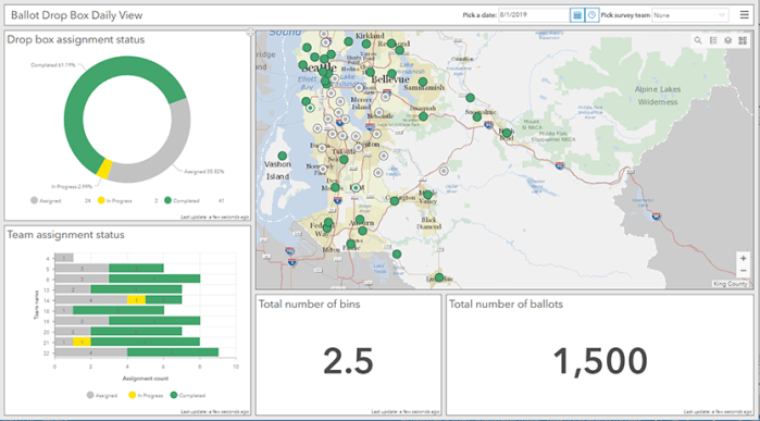
The workflow includes Operations Dashboard for ArcGIS for viewing and monitoring the status of assignments using real-time data for each driver team. These dashboards provide Elections office staff a comprehensive live view of how the ballot collection is progressing. Charts, gauges, and maps deliver powerful visualizations and an approximate count of the number of ballots collected. Location tracking helps show where each team is at a given time.
A simple application was configured with Esri’s Web AppBuilder to enable Elections staff to examine all of the spatial datasets for the project in a familiar web-map environment.
Although this transition to an all-digital workflow relied on a series of Esri products, which fits into the overall commitment of King County GIS to the Esri platform, for one part of the workflow—routing to the drop boxes—Esri’s routing software, Navigator for ArcGIS, was determined to not provide the most efficient options at this time. (This will be re-evaluated as Esri makes improvements). Driver-team assignments typically involve multiple drop-box locations, and the routing software Routific is used to develop overall routes to connect multiple locations. As drivers progress from one location to another, they use Google Maps to determine the optimal point-to-point route at the particular time of day.
After a period of testing and review in early 2019, the all-digital tracking process was implemented for the April 2019 special election and the August primary election. The advantages over the previous paper-based tracking system are numerous. First, from an archiving standpoint, digital forms and signatures means that hard-copy forms no longer fill filing cabinets. Real-time tracking of the ballot-collections process helps Elections dispatchers and managers make timely decisions. The driver teams like using iPhones more than clipboards and paper forms. And finally, data-entry error rates have been reduced. In short, the new paper-free tracking process has helped King County Elections carry out a key part of its mission, ballot drop box collections, more efficiently.


Pingback: NSGIC publishes best practices guidance to improve elections with GIS | GIS & You
Pingback: Esri ‘shout-outs’ about three recent KCGIS projects | GIS & You