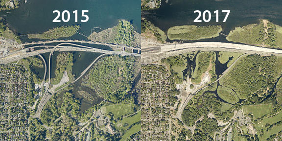
 Frequent users of King County iMap, the online app that provides scores of the most popular King County GIS data layers in a flexible, multi-feature, interactive map viewer, now have access to 2017 aerial orthophoto (straight-down view) imagery as a basemap. The imagery was captured by Pictometry International Corp. from mid-February through October of 2017.
The original photos have a resolution of 3 inches per pixel (“Neighborhood” scale in Pictometry terminology) over urbanized, western King County, and 9 inches per pixel (“Community” scale) over rural, eastern King County. The 3-inch-per-pixel resolution is very close to the scale of the maximum map zoom level in iMap, which means that when you zoom in all the way on a particular location in iMap you can see all of the detail that is available in the original imagery.
Also covered at the Neighborhood resolution level in the 2017 imagery are southwestern Snohomish County, the U.S. Highway 2 corridor in northeastern King County, and the Alpental area near Snoqualmie Pass. There are some gaps in coverage in certain portions of unpopulated eastern King County.
The “Aerial 2017” basemap, joins aerial photo basemaps for the years 2015, 2013, 2012, 2009, 2007, 2005, 2002, 2000, 1998, and 1936 in the iMap basemap gallery.


You could also access aerial images from Landviewer (https://eos.com/landviewer). This service has thousands of images from dozens of satellites updated on a regular basis and free to use. There are also many tools available for image analysis with any Index you need.
LikeLike