Cartographers and GIS analysts often have to make choices about where, within a given map space, to position points that represent real-world features. Shouldn’t be a big deal though, should it? A place is a place, a location a location. It’s just there. You know, where the house or building or parking lot, or whatever, sits on the ground!
Well, it isn’t that simple. Take a house, for example. Should its location be represented by a point that falls more or less near the center of the footprint that the house occupies on the ground, a point which can be represented by latitude and longitude coordinates? Or should its location be represented by its street address, which might be one in an ordered string of points along the adjacent street right-of-way—points which might not even fall within the outlines of the houses they represent?
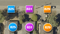 This illustration shows three street addresses that were located automatically on an interactive map, once each from two different geolocation data sources. One of the sources matches street addresses to linear address ranges along the street (represented by the squares). The other matches addresses to points that were pre-defined in their database to represent building locations (the circles). That’s quite a difference between the two sets of results. But does it matter?
 By the way, those are real house numbers in the first illustration. Both address location sources are “smart” enough to correctly place these out-of-order addresses (thanks to prior human intervention, no doubt). But are they smart enough to know if an address doesn’t exist? Many address search tools will show locations for theoretical addresses that haven’t actually been assigned to a house or building, so beware! In the second illustration, 827 and 833 aren’t addresses in the real world but the mapping tools put them on the map anyway. Is it helpful that the tools approximate the locations of unassigned addresses? Or would it be better if they told us that the addresses don’t exist?
 What are the consequences of some of these choices? For cartographers who rely on automated symbol placement, certain location methods can lead to cleaner, more-natural-looking maps, on which, for example, the symbols that represent buildings don’t overlap streets. For map users who need a precise location, such as the only entrance to a parking garage that takes up a whole city block and which is bordered on all sides by frenetic, traffic-laden, one-way streets (with blinding rain pounding down on a murky night as jumbles of signs clutter the view and…aaarrrgh!), a dot positioned in the middle of the block might not be helpful enough.
These examples might be interesting but they’re all pretty low-stakes. Tidy versus untidy maps. A deep breath and an extra circuit of the block to spot the entrance to the garage. And if you look up an incorrectly scribbled street address, then at least a map that locates unassigned addresses would get you close to what is likely the correct location.
But what if the stakes involved in defining a location were higher? What if a point that is intended to represent a general area is mistaken by map users to represent a precise place? What if everyone who lost their cellphone, tablet, or laptop came knocking on YOUR door and accused YOU of stealing it because a map shows that it is in your house!? I have a mapmaker’s interest in the paragraphs above. But I think anyone would be chilled by what resulted from the geographic carelessness detailed in the Gizmodo article “How Cartographers for the U.S. Military Inadvertently Created a House of Horrors in South Africa.” It’s my inspiration for writing this post, and your reward for reading this far. It’s also one very scary answer to the question, “When is a location not a location?”
Patrick Jankanish is Senior Cartographer in the King County GIS Center.


