“Strengthening the GIS Profession”—that was the title of a 2012 ArcNews article authored by my friend David DiBiase. David asked: ‘Is GIS a profession?’ As he pointed out, this is an important question. He defined a GIS Professional as ‘…someone who makes a living through learned professional work…that requires advanced knowledge of geographic information systems and related geospatial technologies, data, and methods.’
The GIS profession, or any profession, rightly requires a definition that defines it across multiple dimensions. This article will assess from a personal perspective where the GIS profession stands today, based on the dimensions of the GIS profession that DiBiase outlined in 2012.
Creating the GIS Profession
Fifteen to thirty years ago those working in GIS had to step up to define the GIS profession on their own. The demand by industry and government agencies for those with geospatial competencies that we had developed on our own was growing rapidly. The mere act of people naming GIS, twenty to thirty years ago, as a focus of their personal careers and of their work responsibilities served as a catalyst for developing each of the dimensions of the GIS profession.

When did you start calling yourself a GIS professional? We are all asked to name our occupation every year on our form 1040. I checked my old IRS returns and I’ve been using GIS as a adjective to describe my occupation for over 25 years.
The Geospatial Work Force
25 years ago, there must have been some head scratching at the IRS as terms such as GIS professional, GIS analyst, GIS technician, GIS programmer, and GIS manager began to appear in the ‘Sign Here’ box on 1040 forms. Six years ago, there were an estimated 210,000 people who worked as geospatial information scientists and technicians.
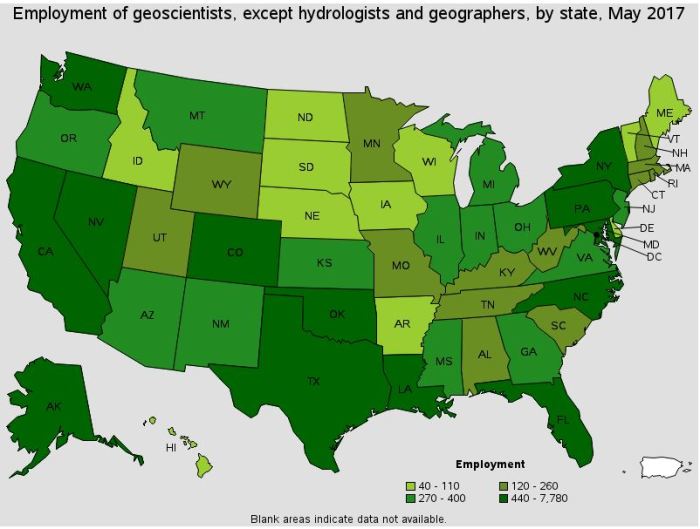
US Department of Labor map of GIS-related employment
Today, the US Bureau of Labor Statistics estimates that 287,000 people work as geospatial information scientists and technicians, 32,000 as geoscientists, 13,000 as cartographers and photogrammetrists, and 60,000 as mapping technicians. (Source: U.S. Department of Labor, National Center for O*NET Development).

GTCM Pyramid Diagram
Today there are at least 150 GIS professionals who work for public agencies in King County. From a personal perspective, my son has now joined the geospatial work force in Portland, Oregon.
Scoping the GIS Profession
To scope the GIS profession, in 2010 the U.S. Department of Labor Employment Training Administration (USDOLETA) published the Geospatial Technology Competency Model (GTCM). In 2013-14 the GTCM was updated to reflect emerging input from employers and GIS professionals about the competencies within the scope of the GIS profession. The GTCM is published on the Competency Model Clearing House. The GTCM also provides a downloadable version of the many individual competencies that fall under the competency tiers shown on the pyramid model. The GTCM supports employers, academics, job seekers, and current GIS professionals with downloadable worksheets to analyze credential competencies, curriculum components, workforce skills requirements, and individual competency gaps.
My personal connection to scoping the GIS profession was serving as co-chair with David DiBiase and Patrick Kennely on the committee that developed the management tier of the GTCM. The Geospatial Management Competency Model (GMCM) had its origins in Lynnwood, Washington during a daylong GIS managers work session at the 2011 Washington GIS Conference. King County GIS Center Manager George Horning participated along with GIS managers from cities and counties in Washington and Oregon. This 2011 work session developed the first strawman draft GMCM. The GMCM was further refined by an international panel of GIS management experts during the 2011 URISA GIS-Pro Conference in Indianapolis. After an extensive open peer-review process the GMCM was published by URISA and adopted by USDOLETA in 2012.
GIS as a Learned Profession
What DiBiase wrote about this in 2012 is still true today. At King County and most other public agencies, GIS staff are considered to be FLSA-Exempt, under the ‘Learned Professional‘ exemption. The Fair Labor Standards Act tests used to determine if the work of a GIS professional qualifies as FLSA-Exempt are address in the Advanced Knowledge and Specialized Education sections, below.
Advanced Knowledge
The advanced knowledge that classifies GIS as a profession was first systematically identified in 2006 by the Geographic Information Technology and Science Body of Knowledge (GIS&TBOK), developed by the University Consortium for Geographic Information Science (UCGIS). A 2017 GIS & You article discussed the development of a new GIS&TBOK, with more detail for each of the hundreds of knowledge area topics. Along with the GTCM, the GIS&TBOK provides a resource for academics, employers, GIS professionals, and career-seekers to understand the essential advanced knowledge for a GIS Professional.
Thumbnail topic entry for the GIS&T Body of Knowledge
The new GIS&TBOK is available online. My entry for the Body of Knowledge, KE-21, System Modelling for Effective GIS Management, was published on September 21, 2018, after a standard peer-review process.
Specialized Education
At least 118 universities in the United States offer bachelor’s degrees in GIS and 94 universities offer master’s degrees. In Washington state, the University of Washington is a leader with programs integrated into the Geography Department and elsewhere. For working professionals looking to enhance or change their skills, the UW Certificate in GIS is a nine-month evening program that has graduated many people who have successfully transitioned to careers using GIS.
The Urban and Regional Information Systems Association has developed a portfolio of daylong URISA Certified Workshops and its renowned week-long GIS Leadership Academy.
My personal perspective on specialized GIS education includes being one of the original authors and former instructors for the GIS Leadership Academy, as well as being certified to teach five URISA certified workshops as part of the King County GIS Training Program. One URISA workshop: Cartography and Map Design, was authored by a team of King County GIS professionals, including Patrick Jankanish (lead author), Cheryl Wilder, Lisa Owen, Dennis Higgins, and myself.
Beginning in January, I will also begin teaching a GIS for Public Policy class at the University of Washington’s Evans School of Public Administration.
Professional Ethics in GIS
GIS professionals agree to abide by the GIS Code of Ethics. Developed in 2002, the code defines the obligations of GIS professionals in terms of obligations to society, employers and funders, colleagues and the profession, and individuals in society. It is still a valid and useful guide.
Certification and Licensure
Professions are also characterized by programs of licensure or certification. Licensure in the US is usually by state boards and covers professions like engineers, surveyors, attorneys, doctors, and dentists. Licensure programs determine who can offer defined services as a professional.
GIS has chosen to utilize certification programs to validate professional qualifications. When DiBiase wrote his article in 2012, there were about 5,000 Certified GIS Professionals (GISPs) certified by the GIS Certification Institute (GISCI). Today, despite the addition of a rigorous exam based on the GTCM and GIS&TBOK to the GISP process, there are about 10,000 GISPs, including seven in King County, about 220 in Washington state, and even two in the Babinski family!
Other GIS certification programs include Esri Technical Certification, ASPRS Professional Photogrammetrist and Mapping Scientist Certification, USGIF Geospatial Intelligence Certification, and in the UK, Chartered Geographers.
GIS Professional Organizations
Professional organizations are a characteristic of a profession. One of the oldest professional organizations involved in GIS had its origins in 1963 at the University of Washington here in Seattle: The Urban and Regional Information Systems Association (URISA). My contribution when I served on the URISA Board and as URISA President was the establishment of the URISA GIS Management Institute. URISA also provides GIS professionals with a comprehensive list of URISA publications, including Model Job Descriptions for GIS, a GIS Salary Survey, the URISA Journal, and the GIS Professional magazine.
A few years ago, several GIS-focused professional organizations created COGO, the Coalition of Geospatial Organizations. Today COGO represents twelve GIS-focused organizations, including URISA, as well as five other advisory organizations.
COGO was instrumental in lobbying Congress over several years for a more rational approach to geospatial data acquisition, standards, sharing and policy. The result was passage by Congress of the bipartisan Geospatial Data Act of 2018, signed into law on October 5, 2018.
Toward a Moral Ideal for GIS
David DiBiase also suggested a moral ideal for GIS. What is a moral ideal? I prefer the term moral imperative. We have a professional obligation to society to use our profession for the good of society. In a 2012 editorial in The Summit I proposed the following as the moral imperative of GIS:
The GIS profession uses geographic theory, spatial analysis, and geospatial technology to help society manage the Earth’s finite space, with its natural resources and communities, on a just and sustainable basis for the benefit of humanity.
The Future
As GIS matures, we are seeing more and more people who use GIS technology, but who are not, nor do they need to be GIS professionals. Many GIS users might not even know that they are using GIS. Other GIS users merely utilize geospatial technology in the form of GIS software to support their business-specific work functions.
But a cadre of GIS professionals provides value to any organization that utilizes geospatial technology on an appropriate, effective, and efficient basis.
What can you do to strengthen the GIS profession?


Pingback: The Role of GIS Professionals in Issues of Equity and Social Justice | GIS & You