The next two King County GIS User Group meetings will feature topics related to the use of GIS for policies related to Equity and Social Justice (ESJ). Within King County government, Equity and Social Justice is a ground-breaking priority approach to focus the County on a pro-equity policy direction.
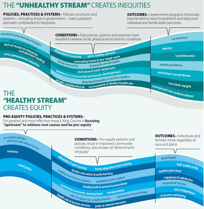
Theory of Change from King County’s ESJ Strategic Plan
Our December 5 KCGIS User Group Meeting focuses on some early efforts to apply geography and later GIS towards issues of equity and social justice, as well as an outline of how King County is beginning to mobilize GIS as a powerful ESJ tool.
The February 6 meeting dives into a case study of using GIS as an equity and social justice support tool.
King County GIS User Group Meeting are free and open to all with an interest in King County GIS. They are scheduled every other month on the first Wednesday, from 11am–12noon. Location: King Street Center, Conference Room 7044-45
December 5, 2018 Feature Topic: Martin Luther King, William Bunge, URISA, and GIS for Equity and Social Justice
Greg Babinski, King County GIS Center, Marketing & Business Development Manager
Nicole Franklin, King County Information Technology, Diversity and Inclusion Manager
Beginning with the coincidence of Martin Luther King, Jr.’s “I Have a Dream” speech and the precursor conference for the Urban and Regional Information Systems Association (URISA) on Wednesday, August 28, 1963, we will survey the role of GIS in addressing issues of Equity and Social Justice (ESJ).
Professor William Bunge, who earned a doctorate in geography from the University of Washington in 1960, anticipated the development of GIS through his work in theoretical geography. Bunge also pioneered the use of quantitative spatial analysis and applied geography as tools to address community-based social issues. Bunge’s time at the UW coincided with the tenure there of Edgar Horwood who first applied computer technology to urban planning. Horwood also organized that August 1963 conference which led to the formation of URISA.
In this presentation we will survey research and publications related to Equity and Social Justice as reported in URISA conference proceedings and workshops, and in the URISA journal, during the past 55 years. We will also outline how GIS is applied to ESJ issues at King County, other local agencies, and academic institutions. King County, which was renamed in 2005 for Dr. King, is a leader in applying ESJ criteria in all of its priorities and programs. We will describe how King County GIS supports this work by creating a rich foundation of data and tools to put ESJ analysis into the hands of everyone within the county and communities that we serve.
February 5, 2019 Feature Topic: Ground-Truthing: GIS as a Community-Based and Anti-Racist Praxis
Veronica Velez, Western Washington University, Associate Professor and Founding Director of the Education and Social Justice Minor
Critical race spatial analysis (CRSA) is a recently developed methodological framework that extends GIS from its traditional use in geography and urban planning into new avenues and possibilities for examining educational interests concerned with the social, cultural, political, and historic role of space and place as it relates to schools and educational inopportunity. By re-imagining how socio-spatial relationships are explored, analyzed, and displayed, CRSA positions GIS as a critical research tool for addressing spatial inequities and furthering racial justice efforts within education and beyond.
This presentation explores the potential of CRSA as critical community-based and anti-racist praxis through a case study of Latina immigrant mothers who initiated a community-led GIS project to explore spatial indicators of educational inopportunity, drawing evidence from their own lives and the lives of their children. These mothers engaged GIS to tell counter-cartographic narratives about the racial divides, or “color lines,” defining uneven geographies of opportunity in their school district. By redefining GIS mapping as a community-based praxis, the mothers “ground-truthed” the maps, revealing spaces and spatial relationships that otherwise would go unnoticed. They transformed the power of the maps to rest not in their “gee-whiz” displays of data, but in the weaving of a spatial narrative that linked their current efforts to historical struggles for educational equity.
Methodologically, their efforts reveal the potential of GIS and CRSA to build spatial models of the world from the lived experiences of People of Color. Beyond the importance of GIS for critical race research, it also serves as an important pedagogical tool for teaching about race and racism. Through a CRSA framework, GIS maps function as teaching devices that highlight the importance of geographical and spatial features for maintaining racial divides in schools and society.
Other Standard User Group Meeting Agenda Items
- Preview of KCGIS 2019 Training Program
- New data updates
- New maps
- Training
- Announcements


