This is the third installment of Where in King County? – our monthly contest that challenges your knowledge about King County and encourages you to learn about the features of King County’s iMap web mapping application.
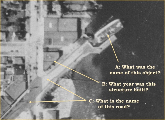
This month Mr. Peabody says ‘Sherman set the Wayback Machine. The year? 1936. The Place? King County, Washington!’ Sherman’s challenge, and yours, is to answer all three questions shown on this image:
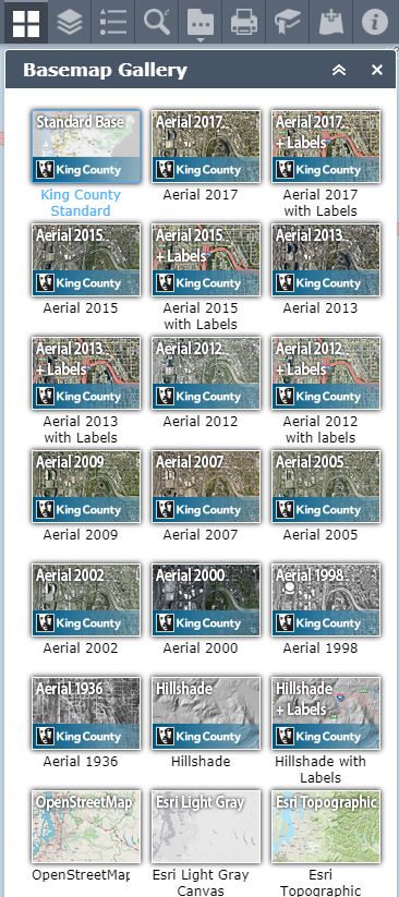
You can set your own Wayback Machine by firing up iMap. Once you’re in iMap, open the basemap gallery. Down at the bottom, you will see that there is an option to select 1936 imagery. Select the ‘Aerial 1936’ imagery as your basemap.
Where did this 1936 imagery come from? It was part of a Works Progress Administration Project to create a comprehensive land use survey of King County. History Link has a fascinating article about this effort, which created hundreds of jobs for unemployed residents during the Great Depression. One of the products of this project was a series of black and white aerial photographs of a substantial portion of King County.

In 2007, a set of the photographs that were held by King County’s Road Services Division were digitized for inclusion in iMap. You can learn more about the 1936 aerial imagery and all of the KCGIS data that you access in iMap in our Spatial Data Catalog (SDC). The SDC entry about the 1936 aerial imagery will tell you facts like ‘what does a sample look like?,’ ‘What are does it cover?,’ and ‘Who can I contact for more information?’
Now that you know about the origins of this imagery, how can you answer the three ‘Where in King County?’ questions? You are going to have to do some aerial photographic interpretation. Simply stated, you have to look at the 1936 photo and make some judgement about what you are looking at. What are the various objects that you see on the 1936 image? Once you have located this spot on the 1936 imagery, remember that you can zoom in and out in iMap. As you zoom in the scale of the map image is increasing and you see a smaller area but at more detail. As you zoom out the map scale decreases and you see a larger area but with less detail.
If you think you’ve found the location shown in the fragment of the 1936 aerial imagery, you could change the basemap back to the Standard Base to get a modern orientation. Ensure that you have the Property Layer turned on. Now you should have access to all the information that you need to answer questions B & C.
For question A, you’ll need to do some real detective work. Here’s one hint. Zoom out in the 1936 Aerial Basemap and look for what’s missing. What’s missing may help you track down the answer to question A.
Answer the all three questions in the comments section below (include your name). The first correct answer received wins and will earn the winner a dandy prize.


A: a ferry
B: 1921
C: E. Madison St.
LikeLike
Sorry Mary. B & C are correct, but A asks for the specific name of the object, not the object class.
LikeLike
I will guess the Leschi Steam Ferry.
LikeLike
Sorry Brian – Not correct. Remember, the contest is to correctly answer all three questions.
LikeLike
A: Lincoln
B: See Mary’s response above
C: See Mary’s response above
LikeLiked by 1 person
Congratulations Mike MacDonald. The vessel shown in that 1936 image was indeed the Lincoln, not the Leschi. Here is a link to the history of the Lincoln: http://www.evergreenfleet.com/lincolnandwashington.html. Send me your email or mailing address and I’ll send you your prize!
LikeLike