OpenStreetMap—An open data community
OpenStreetMap (OSM) is a digital map of the world to which individuals, corporations, and government agencies contribute geographic data which can then be used by anyone under two conditions. First, credit must be given to OSM and its contributors. Second, improvements built on OSM data are required to be available on the same terms.
Started in 2004, the project was inspired by the United Kingdom’s Ordnance Survey, a tax-funded government agency which produced excellent geographic data but charged a fee for use of the data thus restricting its distribution. OpenStreetMap has grown tremendously to include 4.3 million individual contributors in 2017.
There are many uses for OSM data. For example, different user communities focus on maps for drivers, bikers, and hikers. One OSM community in particular represents the way open data can benefit the world community as a whole. The Humanitarian OpenStreetMap Team (HOT) has created a system through which volunteer contributors around the world can use aerial photography for what the community calls “armchair mapping.” A HOT contributor can choose a specific project for which people on the ground in a particular part of the world have identified a local need for mapping due to a crisis. They are given instructions on what features need to be mapped and details about how features such as buildings and roads should be categorized to meet the needs of the project. After contributors add features to the map remotely, people who are present on the ground can check the contributed data locally. And then, thanks to the more complete map, local agencies and individuals can more quickly provide the assistance that is needed in the areas shown on the map.
Another volunteer mapping initiative, Missing Maps, was founded by the American Red Cross, HOT, and other nonprofit organizations to recruit HOT contributors and organize events to bring contributors together to focus on urgent HOT projects.
An OpenStreetMap edit session.
© OpenStreetMap contributors
What’s government got to do with it?
The last annual OpenStreetMap US conference, State of the Map US (SOTMUS), was held in Boulder, Colorado, October 20-22, 2017. Agencies from all levels of government were present sharing their contributions to, and benefits from, the freely available data. Talks were presented by the U.S. Geological Survey, NASA, the Colorado Secretary of State Business Intelligence Center, and the Denver Regional Council of Governments. Other government agencies, such as King County, Washington, and the Wyoming Department of Transportation sent representatives to learn about the OSM community and what it has to offer.
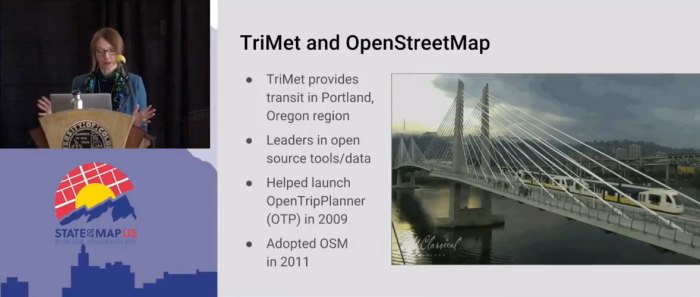
Of particular interest is the successful example of TriMet, the regional transit agency for the Portland, Oregon, metro area. They presented a new use of OSM data for pedestrian routing. A valuable lesson to learn from their example is the importance of data-acceptance testing. Because OSM accepts data from all contributors for immediate inclusion in the map, there is a risk that data TriMet relies on for their business could be invalid. In order to prevent this, a copy of the public OSM database is tested by applying basic data-quality checks and running routing queries that have known solutions. For production applications TriMet uses the tested copy. In the event that the database does not pass the tests, edits are made to the database before it is promoted to production. In compliance with OSM licensing all edits are contributed back to OSM.
“Mapping Sidewalks for Pedestrian Routing” by OpenStreetMap US
licensed under CC BY 3.0
SOTMUS also featured dialog among open data proponents from local governments, civic activist organizations, and the OSM community. One example was the OSM ❤ Open Data forum, which included a good discussion of the important point that you can’t expect open data to meet everyone’s expectations on the first try. That issue can be addressed by fostering communication between the open data-consuming public and the data-producing government agencies.
Imagine the possible
In addition to individuals committed to the open-data-focused OSM community, many corporations have realized that they benefit themselves by participating in the community while they are also contributing to and increasing the value of OSM data for all. Telenav and Mapbox use OSM data as a foundation for navigation products that allow them to compete in the marketplace with Google. Neither Telenav nor Mapbox has the organizational capacity to create their own proprietary digital map of the world as Google has done.
Esri, a longtime commercial GIS software vendor, recently made a donation of a worldwide aerial photography dataset for use as a reference when adding features to OSM, earning goodwill and publicizing their data products. Microsoft (Bing Maps) and others have made similar contributions in the past. At SOTMUS Esri also announced a tool to help those local governments which maintain GIS data in Esri’s proprietary format, such as King County, contribute their GIS data to OSM easily while also meeting OSM community data standards.
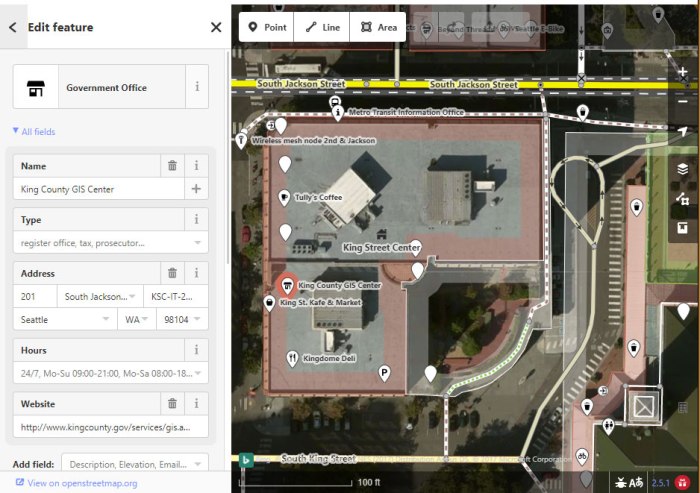
Like many local governments, King County has a strong commitment to equity and social justice and to open data. The King County GIS (KCGIS) Center has published many GIS data layers for years, and it recently unveiled a new open GIS data site that is capable of working with the tool Esri announced at SOTMUS.
Unfortunately, also like many other local governments, KCGIS releases its data under a license that is incompatible with the OSM license. By donating carefully vetted GIS layers to the OSM community and using their tested licensing practices, governments such as King County could leverage even greater value for their existing GIS data through the addition of OSM features. This could simultaneously satisfy business needs, further social justice and open data goals, foster civic activism, and contribute value to the world OSM community which itself fosters equity through efforts such as HOT projects.
References
Paul McCombs is a GIS analyst in the KCGIS Center.


This is a great post thaanks
LikeLike