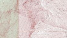
Where in King County? Name this mountain.
Last month we introduced a new GIS & You feature—a (hopefully) monthly contest called Where in King County? This month’s contest is more difficult.
Last month we introduced a new GIS & You feature—a (hopefully) monthly contest called Where in King County? This month’s contest is more difficult.

I often get asked for advice by my GIS colleagues about GIS program management, GIS strategic planning, organizational structure, and how to communicate GIS development concepts to upper management and IT staff. Questions come to me from agencies large and small.

Its time to register for training in Seattle to build your GIS skills. Face to face, instructor-led training builds a solid foundation in GIS to advance your career. The King County GIS Center is offering two-day ArcGIS Fundamentals in September and three-day Intermediate GIS Concepts in October. ArcGIS Fundamentals Overview ArcGIS is a powerful and…

“In those days Caesar Augustus issued a decree that a census should be taken of the entire Roman world. And everyone went to their own town to register.” (Luke 2) Fast forward 18 centuries and the US Constitution states: “The actual Enumeration [of every free person] shall be made…every subsequent Term of ten Years, in…

Among the fundamental skills required to be map literate, that is, to be able to read and comprehend maps, are an understanding of scale, the recognition of spatial orientation, and an appreciation of map projections. A higher-level, overarching principle of map literacy is that a single map can seldom tell a whole story, which is a point well made by Dr. Kenneth Field, Esri senior cartographic product engineer, in a recent article in Wired.
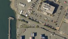
We are introducing a new monthly contest called “Where in King County?”
Each month GIS & You will present a portion of a map either published on the King County website or produced from a King County GIS web-mapping application, like iMap or Parcel Viewer. Each contest will also spotlight some of the features available from the web-mapping applications and some cartographic concepts that can help make you a more effective map user.

You’ve heard about vector tiles. You’ve used vector tiles in a variety of online maps, perhaps without even realizing it. But have you created your own vector tile maps?

King County GIS Training Program partner Eric Pimpler of Geospatial Training Services has authored a fascinating blog post about a building footprint dataset which Microsoft has generated from Bing aerial imagery using artificial intelligence, deep learning, and computer vision.

Fortunately for us in King County, we are well-served by a diverse network of stormwater facilities. King County’s Water and Land Resources Division (WLRD) is responsible for the stormwater system in unincorporated King County. Recently, Alison Sienkiewicz, WLRD stormwater pollution prevention inspector, wrote an article about a team that used GIS tools in the field to map and inventory the King County stormwater system to comply with requirements of the County’s Phase 1 Municipal Stormwater Permit.

There are a few seats left for our two-day ArcGIS Pro Quick-Start class here at the King County GIS Center in Seattle, Monday and Tuesday, June 18-19. Learn more and register online today! Overview With fast processing, enhanced 3D capabilities, and a new intuitive interface, ArcGIS Pro promises a wealth of potential for experienced GIS…

