The sixth offering of King County’s introductory workshop, GIS for Equity and Social Justice, is scheduled for May 11, 2020. It will be presented live online via Zoom.
Read what a student from a recent session of the workshop wrote about the training in this Puget Sound Clean Air Agency blog article. See below for full workshop details.
Overview
This workshop will serve as an introduction to recent trends and practices related to using GIS for equity and social justice (ESJ). We will explore critical race theory (CRT) and trends in critical race spatial analysis. We will review recent literature and academic programs around the topic of GIS for ESJ. Most importantly we will outline best practices for GIS professionals in doing GIS for ESJ work. This includes creating a data/mapping/application support framework both for their own work and to support the work of non-GIS professionals.
Audience
- GIS professionals interested in ESJ work.
GIS professionals are guided by the GIS Code of Ethics , which exist to “help professionals make appropriate and ethical choices,” to consider the impact of their work on society. For hundreds of years mapping has sometimes been a tool for creating and preserving inequity. During the past 25 years there have been some uses of GIS for issues related to equity or social justice. - ESJ practitioners interested in using GIS for ESJ planning, analysis and program monitoring.
ESJ practitioners who are not GIS professionals will become the largest community doing ESJ work with GIS. These non-GIS professionals include those who work for agencies, non-profits, and NGO’s with an ESJ mission, as well as government policy professionals who want to use GIS to support an ESJ lens for developing upstream agency policies.
Agenda and Topics Covered
- Introduction and grounding exercise
- Why GIS for equity and social justice (with class exercise)
- Understanding how maps and GIS can be used to create long-term inequity
- Critical race theory (with class exercise)
- Principles of equity and social justice
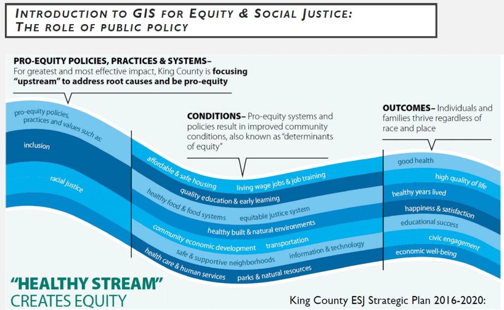
- How upstream policies impact downstream outcomes
- The role of public policy
- GIS code of ethics and moral imperative
- The role of GIS professionals
- Critical race spatial analysis
- How GIS and maps can expose oppression and inequity
- The role of ESJ practitioners
- Best practices for GIS professionals doing ESJ work (with open discussion)
- How GIS can be used to manage and monitor pro-equity policies (demo Esri-King County ESJ dashboard)
- Examples of public agencies with ESJ policy priorities
- Educational resources for GIS professionals
- The URISA GIS for ESJ workgroup
- Bibliography and acknowledgements
- Final discussion, evaluation, and call to action
Recommendations
Familiarity with GIS tools, such as ArcGIS or QGIS, and business analytics tools, such as Tableau, Power BI, or Insights.
What You Will Receive
- 4.0 hours of instruction
- A copy of the workshop training materials.
- Upon completion, a signed completion certificate which will indicate the CEUs (0.4) and GISCI (0.10) points earned.
Our Students Speak
“This was interesting and informative.”
“Well done…this was useful…a ton of information.”
“Great introduction to this topic.”
Register for GIS for Equity and Social Justice today!


