I get two or three requests every month for GIS career advice from young people considering a geospatial career, or working adults interested in shifting their career towards GIS. My GIS career path was extremely convoluted, and I think that is the case for many people who want to join the ‘GIS Tribe.’ I came across a very interesting LinkedIn article from Nathan Heazlewood, GIS Consultancy Practice Lead at Eagle Technology in New Zealand. Nathan has agreed to let me reproduce it here in its entirety. Here are Nathan’s thoughts on a GIS career model.
“I have been talking to recent graduates that have commenced their careers in the geospatial industry. I have been explaining to them my perspectives on the nature of the industry and what skills they might want to develop in order to progress their careers. As part of these discussions I created a couple of models that I thought might interest others.
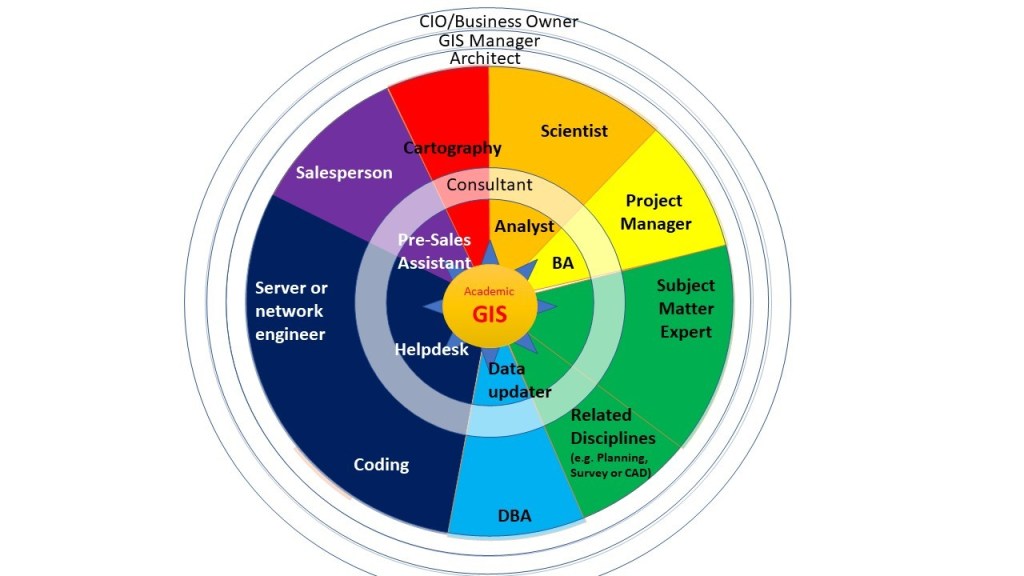
“The first model below indicates some skills/positions that someone with an interest could look to get experience with to enhance their careers. Starting at the center of this diagram and moving outwards there are various skillsets that an emerging GIS professional could aim to get experience with. The regions with ‘Consultant’, ‘Architect’, ‘GIS Manager’ and CIO/Business Owner are represented as a ‘ring’ to indicate that often those roles require knowledge of at least some of the ‘wedge’ shaped roles.
“Some important notes with this is that it is perfectly normal to progress within each ‘wedge’ without necessarily needing to get to one of the outer rings: e.g. you have a great career being a ‘junior’ cartographer, then progressing to an intermediate and senior cartographer without necessarily needing to aim to become the CIO of a major corporate enterprise (and the same applies for all of the other roles/skillsets).
“Another way of looking at this is the complex looking diagram below (which I will break down and explain further):
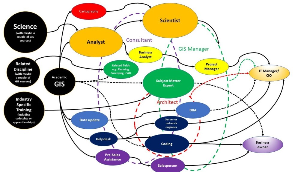
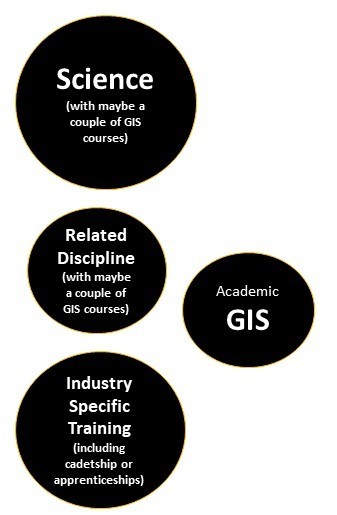
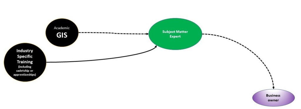
“Some notes about this diagram: you don’t necessarily need to major in university GIS to start working in the GIS industry: many people get into GIS from related science studies, such as geology, environmental science, statistics, computer science or data science. Many people also come into GIS from studying a related subject area such as urban planning, surveying or CAD. Others come into GIS through working in a specific industry and then developing Subject Matter Expertise (SME) skills in that industry: I know many people like this that did not even go to university: there are many people particularly in the telecommunications, utilities or agricultural sectors that started out working in those specialities (perhaps as a cadet or apprentice) and gradually started using GIS and got more and more into it.
“It is also important to point out that although my diagram indicates some ‘likely paths’ and ‘less likely paths (dashed lines) these shouldn’t be taken to indicate that those are the only paths- it is fully possible for someone working in any of these roles to take a career change or retrain to do any of the other roles: e.g. it is perfectly possible for a cartographer to change careers to become a salesperson and then to start their own company etc (even though that path is not represented in the main diagram).

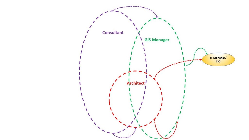
“Another element of my model is that there are certain roles (in the background) where at least some skills from many of the roles in the foreground are required: e.g. to become a GIS consultant or GIS Manager it is handy to know at least a bit about coding, databases, cartography, servers and networking and business analysis etc.
“It is also important to highlight that some of the disciplines indicated on the diagram are obviously much larger than GIS itself: for example while many different types of science use GIS (geology, demographic analysis, health analysis, vulcanology, data science) etc for many of those sciences GIS is a tool that is used for a fraction of the overall work that they do and they have a wealth of knowledge about their chosen topics that fall outside of the scope of GIS.

“Similar to the paragraph above, the same situation occurs with SMEs: someone working in a particular specialty (and there are hundreds that use GIS) may only use GIS for part of their work (in the forestry industry for example: an industry specialist in forestry might make use of GIS, but that doesn’t mean that it is necessarily easy for a GIS person to automatically become a forester without additional training).
“Lastly another key element of developing your career is ‘soft skills’ (people skills). In the company that I work for we have a saying ‘all staff are in the sales team’: what we mean by this is that all of our personnel need to represent our company well. We train our staff to act in a professional and friendly, positive way with our clients, and that is not just the account managers that deal with the clients often, but also the technical personnel that may come into contact with clients less often. We are aiming to be trusted by our clients and that means acting with integrity and delivering what we promise.
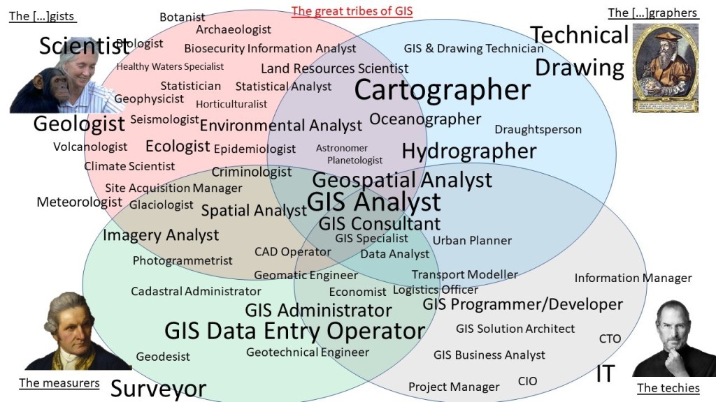
“Note also: for the purposes of simplification I have used some ‘grouping’ of just a handful of the possible GIS career job titles in the explanation above. There are of course hundreds of other job titles where GIS skills are important. A wider listing of some of these job positions is shown in the diagram below (however note that even this is still no-where near a complete list!)
“Hopefully this might help a few other people with planning their careers. Thoughts are my own and do not necessarily reflect the views of my employer or any 3rd party.“
Connect with Nathan on LinkedIn at: https://www.linkedin.com/in/nheazlewood/


