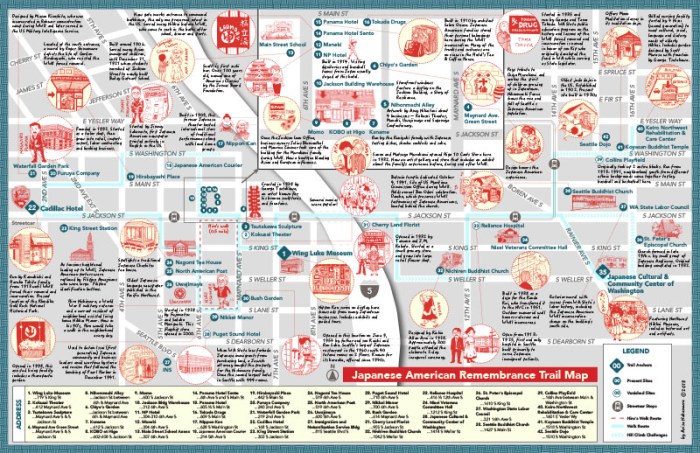
One of the most satisfying things that a well-made map can do is convey a sense of place. And an especially well-made map may convey a sense of a past place that both infuses and transcends a present location. I came across such a map yesterday just a few blocks from our own King County GIS Center location, where Seattle’s Pioneer Square transitions to the International District, specifically the historic Japantown.
Japanese American Remembrance Trail Map by Arisa Nakamura ©2018
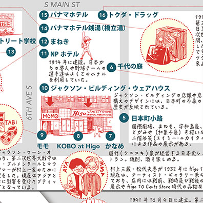
Detail, Japanese-language version
Arisa Nakamura ©2018
The “Japanese American Remembrance Trail Map” somehow seems larger than its modest tabloid print size, due in no small part to the numerous delightful and intriguing hand-drawn illustrations of people and places throughout the ID that are spread across the map, fusing past and present. For us in the present, the map serves as a walking tour of current sights, sounds, tastes, and touch, which can all be gateways to the rich Japanese American legacy in Seattle, a cultural story that continues into our city’s future. (Coincidentally, as I write this I am hearing a radio announcement for this weekend’s—April 20-22—Seattle Cherry Blossom & Japanese Cultural Festival, which two of my KCGIS Center colleagues will be participating in.)
The trail map—as useful as it is a great piece of art—was designed and illustrated by Seattle’s Arisa Nakamura. Read more about her work on the map in this article in The North American Post. The map is available in separate English- and Japanese-language versions at locations throughout the Chinatown/International District, including the Wing Luke Museum of the Asian Pacific American Experience, which is one of the anchors of the Japanese American Remembrance Trail. The Wing Luke Museum website has a section about the trail tour and links to PDF files of both versions of the map.
As the late winter, early spring chill finally relinquishes its grip on Seattle, it’s the perfect time to put on your walking shoes and let a wonderful map lead you through and teach you about a special part of our city.
King County Metro Transit, Downtown Metro Service map (King County GIS Center)
Patrick Jankanish is Senior Cartographer in the King County GIS Center and is a member of its Spatial Services group.


Nice post and great discovery.
LikeLike