In August 2023, Public Health and the GIS Center launched a new map-based application for searching septic and Group B water system records. The app consolidates information previously spread across several website applications, databases, and tools and helps streamline user experience. In this post, we’ll focus on the technical side of the project.
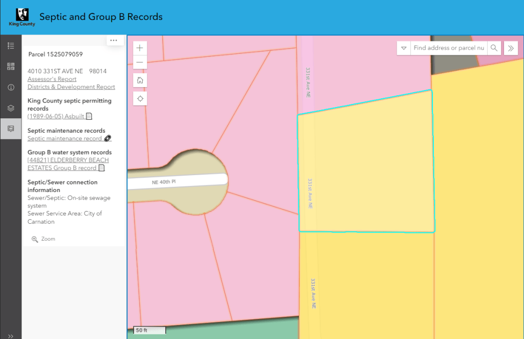
Figure 1: King County’s Septic and Group B Records search application screenshot showing septic-related records for a selected parcel number 1525079059
Public Health – Seattle & King County track on-site sewage and septic systems within the county. These are systems not connected to larger public wastewater systems. They also keep documents related to Group B water systems, which are small public water systems that might serve a handful of parcels. These include documents like as-built plans, permits, inspections, and maintenance.
This information is helpful for several audiences. Homeowners may want to check records for their property. Potential home buyers may want to research if there is an existing or decommissioned septic system on a property. Companies doing maintenance or inspections may want to access records they’ve filed with Public Health. Real estate professionals are also interested in the records to learn more about existing conditions and assess potential improvements to a property. Public Health makes use of the records for their work.
Existing digitized records are spread out among several systems. One of them was not directly accessible to the public, resulting in many manual records requests. Another third-party system was not particularly easy to use. A major downside of having so many disparate systems was the need for more context — the ability to see what was around a given property or things like sewer district information. By putting all the information in one place and giving it a more interactive map element, discoverability, and context were improved.
For this all to appear straightforward to the users, most of the work had to occur on the back end. For the maintenance records and document systems referred to as EDMS (Electronic Document Management System), we set up linked servers in the enterprise geodatabase. We also worked with a vendor to provide weekly data updates in an Azure database, allowing us to access accurate data easily. With all data accessible in one database using linked servers, we were able to create SQL Server views and spatial views relating properties to their available records. (A side benefit is that it also streamlined quality control and error checking, allowing us to quickly query and capture records with incorrect or invalid information so they can be corrected.) With all systems directly linked, we could automatically push updated records to the application every night.
We used the ArcGIS API for Python for nightly tasks. One script exported the spatial views to feature classes, managed relationship classes, exported features to a ZIP file, and updated a hosted feature layer on ArcGIS Online. Due to the size of the dataset and the built-in relationship classes, we found it was most straightforward and least error-prone to overwrite the layer with a new (zipped) file geodatabase rather than use record-by-record edits for changes. Another script reports quality control checks and emails the results to Public Health staff.
As for the document storage system, we needed a way to provide access to documents behind our firewall. Fortunately, the system had a web service that we could leverage. We used Azure API Management to create our own API endpoint that translated requests to the Content Store webservice. The API endpoint had fewer parameters and options and handled all of the server-side authentication. We could also store any sensitive information in an Azure Key Vault. This protected the back-end database and service, allowed for public web access to documents, and maintained a low overhead without building an entire custom intermediate application. With a single link calling the API endpoint, we could return binary PDF data.
Now that everything was linked together on the back end, it was time to make the actual front-end application. After a few rounds of prototypes and testing with our partners in Public Health, we found that an ArcGIS Online Instant App (“Sidebar”) was the best solution for us. We created a web map with only a few layers for simplicity – a layer symbolizing the parcels by their wastewater treatment type, a layer highlighting parcels that have septic and Group B water system records available, and a point layer of Group B groundwater well locations. For situations with more map layers, King County’s iMap application is available with Septic and Group B data layers. The Septic and Group B Records app is intended to focus on this particular topic.
The app provides the ability to search by either address or parcel number. Results auto-populate the sidebar, which is linked to the feature pop-up for the layer. To keep interactions simple, this pop-up contains all relevant information for a parcel. By including related tables as part of the primary map service, we could use Arcade expressions to query related records and provide document links if they are available. We also used Arcade for geographic queries to return information on sewer service areas and districts.
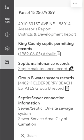
Figure 2: A screenshot from the application showing the results of the selected parcel in the sidebar.
All in all, the little bit of extra infrastructure went a long way in providing a flexible base to build the application. By putting the more complex logic on the back end and gradually simplifying as we got to the front end, we could use a standard ArcGIS Online web map and off-the-shelf Instant App, lessening long-term maintenance obligations.
The application has been well-received by both internal and external users for its ease of use, time savings, and increased access to records. This application has generated positive feedback from public and internal customers, such as, “I really like the new site. It has everything we need on one site,” and” This tool is great! Having easy access to these reports should help eliminate errors.” It was a pleasure working with Public Health on this project. We used an Agile approach that allowed us to collaborate closely, provide updates, incorporate feedback, and land on a solid solution that saved both time and money.
https://kingcounty.gov/SepticRecords

About the author: Fred joined King County in 2012 and has a background in civil engineering and hydrology. In the KCGIS Center, he focuses on application development, automation, and analysis. His work supports equity, environmental, and infrastructure efforts across the county.


