Understanding GIS software usage at King County, WA
Given that ESRI is ending support for ArcGIS Desktop in 2026, the King County GIS Center needed to understand the migration of users from ArcGIS Desktop to ArcGIS Pro. Specifically, we wanted to know who is using ArcGIS Pro and how often they’re using it. Today we have that metric, thanks to an app I built using the ArcGIS Portal Directory API. ArcGIS Portal Directory REST API—ArcGIS REST APIs | ArcGIS Developers
For ArcMap usage, we have an on-premises license server that we instrument using a tool called OpenLM. This allows us to capture when and to whom the license server issues licenses. This data allows us to paint an accurate picture of ArcMap usage by King County employees. Today ArcGIS Online is our preferred license management solution. This means that OpenLM can’t help us to understand usage for ArcGIS Pro and ArcGIS Online. But we can use ESRI’s Portal APIs to pull our data out of ArcGIS Online.
Getting the Data
To understand ArcGIS Pro usage at King County we need to answer two questions: who is using ArcGIS Pro and when are they using it? Based on the username, we can get a list of login events from ArcGIS Online API. They also contain an AppId that tells us what application is being used, e.g., ArcGIS Pro, ArcGIS Online, Survey123, etc. We can filter this AppId for all the logins that occurred for ArcGIS Pro.
A login event only records the instant that a user started working in ArcGIS Pro. However, once a login token is issued, it needs to be refreshed periodically. Typically, a token is refreshed every 15 to 20 minutes. Thus, in a single session of, for instance, updating the symbology of the county base map, a dozen or more ArcGIS Pro login events may have been recorded for a username.
First, we split the login events out by the day. Second, we count usage from the first time you logged in to the last time you logged in to estimate how much time you are using ArcGIS Pro. The same methodology is used to help us understand usage in ArcGIS Online. The difference is that we filter the AppId for ArcGIS Online, not Pro.
For ArcMap usage data, we leverage an existing tool called OpenLM. This is a commercial off-the-shelf product that the county has used since the turn of the last millennium. License Management Services | Software Licensing Solutions (openlm.com) This solution allows me to query the supporting tables for OpenLM to retrieve a list of usage entries, group them by the username, and -compare ArcGIS Pro and ArcGIS Online data.
Whose username is that?
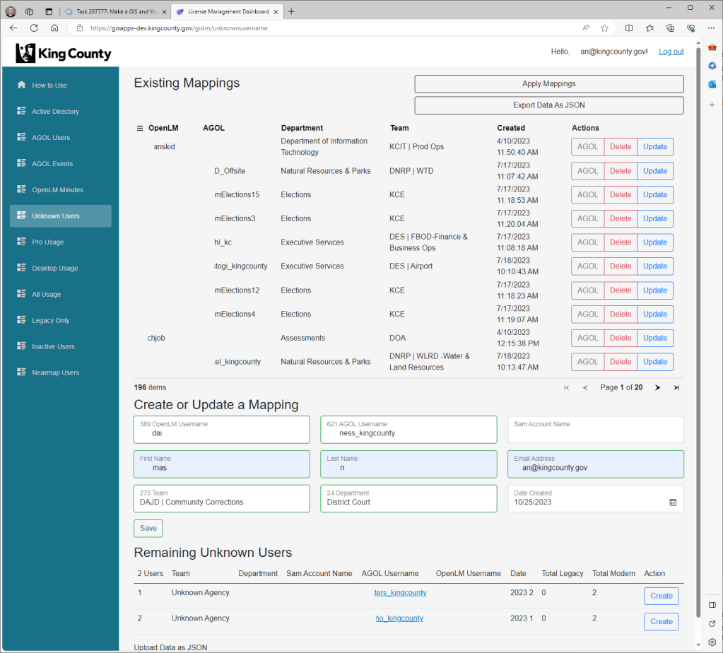
Now that we’ve gathered our usage data and organized it by username, we need to map the ArcGIS Online and ArcMap usernames to accounts in the County’s Active Directory instance. This is more complex than it may sound. The usernames reported by OpenLM are from the Windows user profile on the machine where ArcMap was opened. This profile is created the first time you log in with your Windows user to a specific machine so it may not match with your current account in Active Directory.
The county now uses a single sign-on solution to log users into ArcGIS Online, but we didn’t always. So… many King County GIS usernames cannot be matched to their accounts in Active Directory as they are different and do not follow a specific pattern.
As an example, for an Active Directory account with an email of “waldotobler,” we must match it with an ArcGIS Online username of “wallyGIS” and an OpenLM username of “wtgis”. There’s not a great way to do this. In the before times, this was managed in an Excel spreadsheet and a pivot table.
In my application (GISLM), this is handled with a page called Unknown Users. After ingesting data from Active Directory, OpenLM, and ArcGIS Online, employees can review all available username values from the three data sources. This enables the creation of a mapping from a county employee’s Active Directory data to their usernames in ArcMap and ArcGIS Online. It’s still a complex and tedious process to work out the relationships between employees and usernames but that’s the nature of this problem.
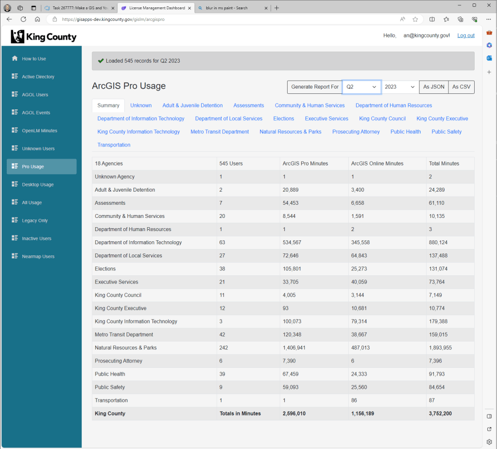
Now that we’ve gathered up the data and worked out who’s who, we can finally produce some reports. First off, we have the Pro Usage page where you can see a table of usage parsed by the county agency, number of users, and time spent in ArcGIS Pro or ArcGIS Online. Then we have the Desktop Usage report. This report breaks out ArcMap usage by Agency and license type. These reports are tabbed so you can review users from any agency/department and compare yourself to your coworkers.
Answering every question
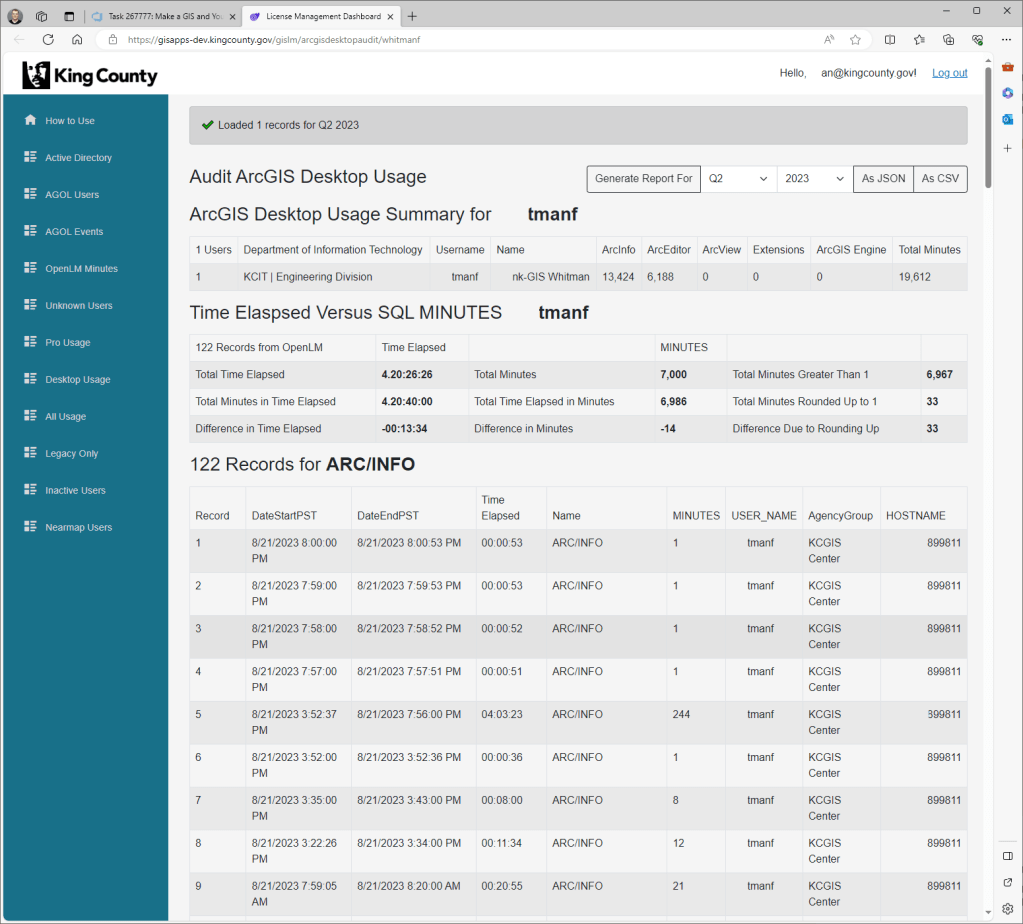
At first, I thought that this was enough. But when we started demoing my app (GISLM) to GIS Center staff, I kept getting questions like. “Yeah, okay, but that’s not my real ArcMap usage. I don’t remember what I was doing on that day, but it wasn’t that! Your tool must be rounding wrong. These numbers just don’t add up!” Thankfully GIS is a form or subgenre of Data Science, so I am not afraid to give you the individual rows and sums from OpenLM and the ArcGIS Portal Directory API that we used to generate the report. After a lengthy review of the data, the numbers in these reports were confirmed empirically.
This can be proven by clicking on any individual username in a usage report to bring up the Auditing page for that username. This will show you a nicely formatted version of the data that is used to calculate usage for your username. Just like the main reports, we’ve included options so you can export everything you see to JSON or CSV and leverage this data for your projects.
Transitioning to ArcGIS Pro
To that end, we’ve developed a couple of use cases for this dataset such as generating an index of employees based on how they’re using ArcMap compared to ArcGIS Pro. This is a tricky problem because we have many custom tools and business processes that rely on ArcMap here in the county.
It’s helpful for us to know who the ArcMap “holdouts” are because typically entire agencies have application version dependencies and cannot migrate to ArcGIS Pro. Our goal at the GIS Center is to make the transition to ArcGIS Pro as seamless as possible. Knowing who’s blocked allows the GIS Center to better prioritize.
Then we have the Inactive Users report! When we are matching up ArcGIS Online and Active Directory data, we’ll sometimes find accounts in ArcGIS Online that can’t be matched to someone in Active Directory. Often, this is because they’ve left the county at some point. The county has a vested interest in cleaning up these inactive users of ArcGIS Online. This report tells us who those inactive users are.

In summary, we now have hard, reproducible usage data for ArcMap, ArcGIS Pro, and ArcGIS Online at King County GIS. Using my app, we can tell you how many minutes you spent in ArcMap last Tuesday and how many ArcGIS Pro minutes on Friday morning. We can also report on the agencies that have made the transition to ArcGIS Pro and those users that need help with this software transition. The GIS Center is here to help. BTW, the answer to “Who is using ArcGIS Pro anyhow?” is (on average) about 450 people daily at King County. 3 out of 4 GIS software users have made the transition to ArcGIS Pro! You can check on our progress on the new State of GIS website. state-of-gis-kingcounty.hub.arcgis.com

About the author: Thomas Ryan is a Principal GIS Data and Platforms Engineer on the GeoData team at the King County GIS Center. Tom enjoys programming in C# and JavaScript. In his free time, Tom is an avid skier and bicyclist (depending on the weather).


