Working from home since March means my unabridged Random House Dictionary is always just three feet away. Here is an entry…
Cat·a·lyst (n) 3. A person or thing that precipitates an event or change.
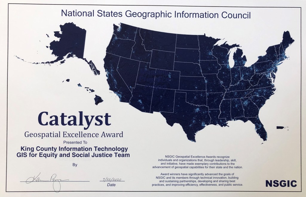
At its 2020 Annual Conference, the National States Geographic Information Council (NSGIC) presented its Geospatial Excellence Catalyst Award to the King County Information Technology GIS for Equity and Social Justice Team.
Quoting from the award…
“The NSGIC Geospatial Excellence Awards recognize individuals and organizations that, through leadership, skill, and initiative, have made exemplary contributions to the advancement of geospatial capabilities for their state and the nation. Award winners have significantly advanced the goals of NSGIC and its members through technical innovation, building
and sustaining partnerships, developing and sharing best practices, and improving efficiency, effectiveness, and public service.”
To be considered for a Geospatial Excellence Award, an individual or organization must meet at least three of the following criteria:
- Creates a sustainable partnership or initiative that returns significant benefit from geospatial technology across multiple organizations
- Advances the ‘create it once, use it a bunch’ credo for efficiently delivering valued geospatial data and services across a broad enterprise of users
- Benefits the whole nation through sharing of innovation or establishment of best practices
- Promotes NSGIC goal of efficient and effective government through increased, prudent adoption of geospatial technologies
The nomination of the King County IT GIS for ESJ Team for this award was first recommended by Elizabeth Lanzer, Washington Department of Transportation GIS & Roadway Data Branch Manager. The nomination for the award was submitted by Joanne Markert, Washington State GIS Coordinator. Markert noted that “King County began this work before equity became a national issue. They have been leading on equity issues for our state and our nation and we are proud to nominate them for this distinguished award.”
King County IT’s GIS for Equity & Social Justice (ESJ) Team has developed an innovative methodology for government agencies to analyze any policy, project or program. The King County GIS for ESJ approach is to use spatial data and geospatial analysis and visualization to identify underserved communities—areas where the needs are greatest, and then to monitor the impact of programs designed to increase equity. The KCIT GIS for ESJ Team also developed a first-ever, half-day GIS for ESJ workshop and a peer-reviewed GIS for ESJ Best Practices document.
The focus of the King County IT GIS for ESJ project was to create methodologies and geovisualization dashboards that would inform and empower stakeholders within the county, as well as regional partners, national collaborators, and the communities impacted. This empowerment enables stakeholders to apply GIS data, analysis, and visualization related to each phase of a conceptual GIS for Equity and Social Justice lifecycle.
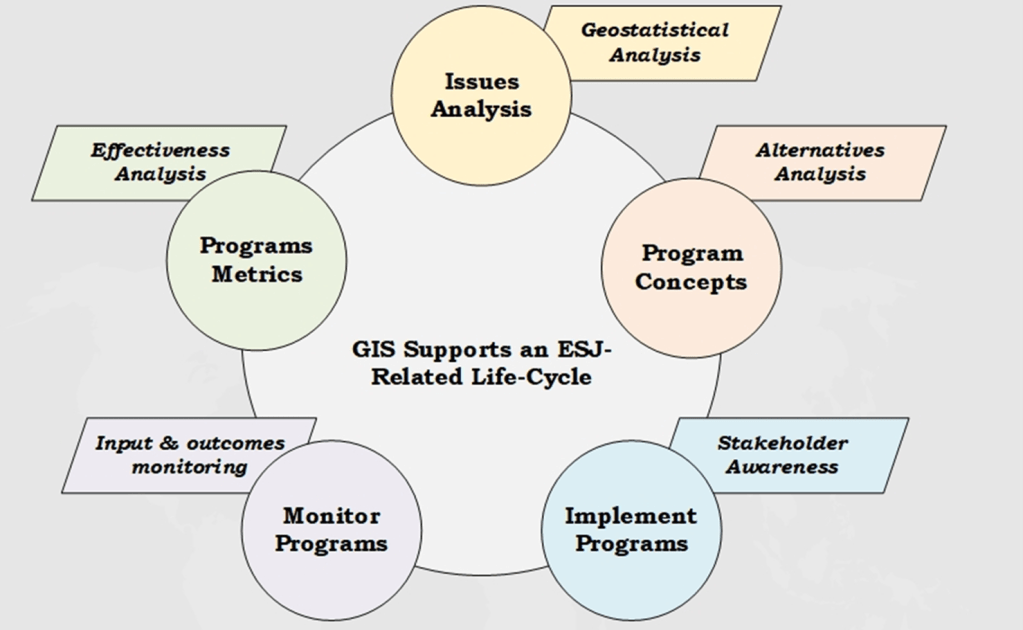
KCIT developed the conceptual GIS for ESJ lifecycle that includes issues analysis, program alternatives analysis, project stakeholder awareness, program management and results monitoring. The KCIT GIS for ESJ team worked closely with Esri to customize ArcGIS Dashboards to incorporate equity-indicator/community-condition, demographic, and program-action data.
The King County IT GIS for ESJ work has been done as part of a broad coalition of GIS professionals and ESJ practitioners. KCIT has worked with every department within King County to develop 39 equity indicators (specific datasets that correspond to specific county work functions) to be used throughout the GIS for ESJ lifecycle, which was developed by this project and documented in the GIS for ESJ Best Practices.
The GIS for ESJ Best Practices document was developed in part via an EthicalGEO Fellowship from the American Geographical Society. It will be published soon as a new article in the GIS&T Body of Knowledge.
More recently the KCIT GIS for ESJ team has been working with the State of Washington to help design and implement a Digital Equity Action Dashboard that will incentivize the build-out of broadband fiber and WiFi hotspots to areas where the need is greatest, not only by the state, but also by other government agencies, non-profits, and the broadband industry, all to achieve equity and social justice.
The King County IT GIS for ESJ team will continue as a catalyst to help advance the equity and social justice based approach to government policy, projects, and programs.
NSGIC promotes the coordinated, impactful, and cost-efficient application of GIS and other location-based information and analytics to best serve the nation, with emphasis on the power of initiatives and public policy that connect across local, state, federal, and private sector partners.


Pingback: King County GIS receives Geospatial Excellence Catalyst Award | Careering
Pingback: Presidential Executive Order on Racial Equity recognizes the importance of geography | GIS & You
That’s really interesting work, great!
LikeLike