The King County Information Technology GIS For Equity & Social Justice Team received Esri’s Special Achievement in GIS (SAG) Award on July 13, 2020, at the annual Esri User Conference. Selected from over 300,000 eligible candidates, King County Information Technology received the award for its innovative application of mapping and analytics technology, as well as thought leadership in the field of GIS for Equity and Social Justice.
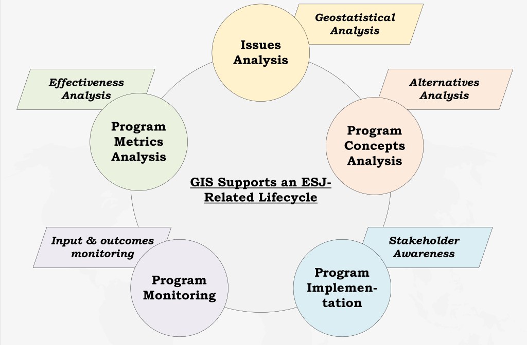
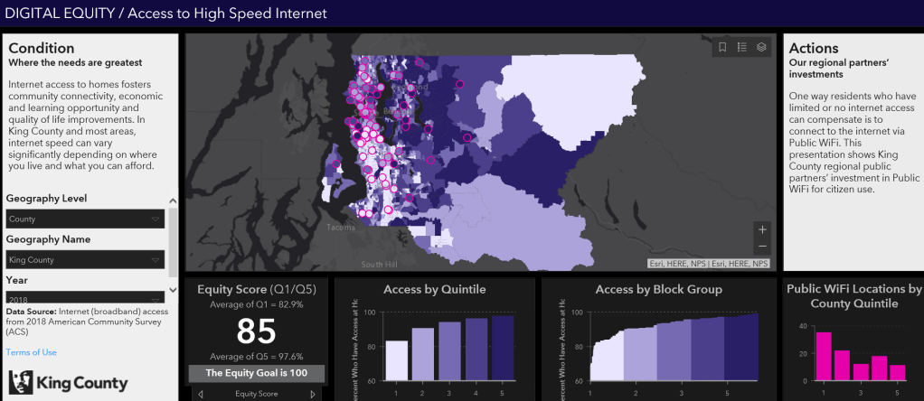
King County’s GIS for Equity and Social Justice program was developed to create methodologies, training and ultimately solutions that leverage or innovate GIS technology to Advance Equity and Social Justice. This includes a GIS for ESJ workshop, the GIS for ESJ lifecycle, and GIS for ESJ best practices. King County’s Project Equity Performance Management (EPM) Methodology and Tools utilized GIS solutions to understand where the needs are greatest. It identifies place-based investment targets and needed performance goals. This replicable process leverages geovisual dashboards that empowered stakeholders, regional partners and communities. Stakeholders apply GIS data, analysis and visualization to conditions in each phase of the GIS for ESJ lifecycle.
The SAG Awards are meant to show appreciation for organizations using GIS to understand complex data and meet challenges around the world. Through their unique approaches to geospatial science, the users honored with awards are demonstrating groundbreaking possibilities of GIS software.
This year’s Esri User Conference was the world’s largest virtual GIS event. The King County Information Technology – GIS For Equity & Social Justice Team was one of over 180 organizations in areas such as commercial industry, defense, transportation, nonprofit work, telecommunications, and government to be honored with the SAG Award. Recipients were recognized by Jack Dangermond during the event. Esri staff annually nominate hundreds of candidates from around the world for consideration, and Dangermond selects the finalists.
“The Esri User Conference has always given our users an opportunity to share the ways they are implementing GIS and using it to improve their organizations and the world around them,” said Jack Dangermond, Esri founder and president. “I am inspired by the amazing work our users are doing, and I am honored to present these awards to all the organizations recognized for their commitment to technological leadership in government, business, and nonprofit work.”
Talking about the teams behind the SAG Awards, Dangermond said… “I think of your work as heroic work. You had to get the idea, assemble the right technology, and software, and organize the data. You had to get management support and build relationships with your colleagues to make things happen. Heroes are people who stand up and get things done. I want to thank you for your effort, but you have a responsibility too. Being acknowledged includes the responsibility to share your innovations so others can build on your work. I wish you well. Stay safe.”
Project team: Nicole D. Franklin led this project as the Chief Equity Officer for King County IT. Developing collaborative and pragmatic solutions to problems faced by unserved and underserved communities is her expertise. This project focused on applying Esri technology solutions for a replicable ESJ performance management process. Nicole holds an MA in Demography – University of Pennsylvania and BA degrees in Statistics, Sociology and Applied & Computational Mathematical Sciences – University of Washington.
Team members:
• Mary Ullrich, GIS Analyst
• Patrick Jankanish, Senior Cartographer
• Mike Leathers, GIS Data Architect
• Dennis Higgins, Spatial Services Manager
• George Horning, GIS Center Manager
• Tanya Hannah, CIO
• Greg Babinski, GIS Business Development Manager
• Yuko Caras, GIS Developer
• Victor High, GIS Analyst
• Harkeerat Kang, GIS Developer
• Stephen Heard, CTO
• Dennis Fong, Software Development Supervisor
• Michael Jacobson, Performance & Strategy Deputy Director
• Karin Collinsworth, Business Analyst
• Fred Lott, GIS Analyst
• Richard Gelb, Environmental Public Health Planner
For more information on how the King County Information Technology – GIS For Equity & Social Justice Team is innovating through the use of geospatial technology, visit http://www.kingcounty.gov/gis.


Pingback: Presidential Executive Order on Racial Equity recognizes the importance of geography | GIS & You
Thank you for sharingg this
LikeLike